


To make agriculture smarter and easier, to keep hunger away from humanity.
Profile of GNSS leveling system and laser system
Release time:
Apr 26,2024
The satellite leveling system uses satellites and base stations to perform differential positioning on the GNSS antenna installed on the leveling machine to determine the current position and elevation of the GNSS antenna, and feeds the data back to the intelligent terminal. The intelligent terminal processes the collected data and sends control signals to the electromagnetic directional valve installed on the leveling machine, thereby controlling the oil cylinder on the leveling machine to work and achieve the required elevation of the current position.
The laser leveling system uses a horizontal laser beam for positioning, and the antenna is divided into three sections: upper, middle, and lower. When the upper end of the antenna receives a laser signal, the controller will determine that the current position of the leveling shovel is too low. The controller sends an upward signal to the electromagnetic directional valve, which controls the oil cylinder to raise the leveling machine to the working plane. On the contrary, when the lower end of the antenna receives a laser signal, the controller will determine that the current position of the leveling shovel is too high. The controller sends a downward signal to the electromagnetic directional valve, which controls the oil cylinder to lower the leveling machine to the working plane. Regardless of whether it rises or falls, the middle section of the antenna receives the laser signal and reaches the working plane.
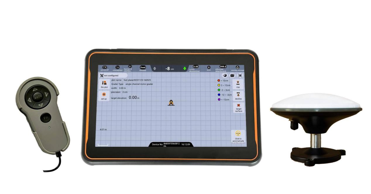
Our company's (Wisdom Beidou) satellite leveling system integrates intelligent terminals and controllers, optimizing product form, effectively reducing product space occupation and improving overall system stability, with high accuracy and good performance. The system has the following advantages:
1. 30 minute quick installation and debugging, easy to learn and use, and more convenient maintenance;
2. 10.1-inch high-definition touch screen, real-time display of work trajectory and elevation, visualization of elevation heat map, improving work efficiency, greatly reducing staff fatigue;
3. Supports flat horizontal planes, inclined planes, and double inclined planes, with adjustable control accuracy;
4. Support various equipment such as graders, scrapers, bulldozers, etc., and support single channel or dual channel control methods;
5. Expandable automatic steering system to save usage costs and create more benefits;
6. Support Beidou/GPS/GLONASS/GALILEO/SBAS, multiple differential methods, and more flexible operation distance;
7. Work 24 hours a day, free from adverse weather conditions such as strong winds, sand and dust, and haze;
8. Equipped with elevation measurement function, it can grasp the elevation difference information of the plot before starting the leveling operation, set the benchmark with one click, and perform quick operations.
The leveled land can save water resources, fertilizer, and improve land use efficiency, thereby increasing crop yields and creating more profits.
Previous page
Next page
LATEST NEWS

Tel.
Mobile:+86 185 6159 2559
Email: sales@wisdombeidou.com
Address:No. 3-32 Changjiang Road, Pingdu ETDZ, Qingdao City, China
Copyright © Wisdom Beidou | SEO | Business license
Phone:
Email:
在线客服添加返回顶部
右侧在线客服样式 1,2,3 1
图片alt标题设置: Wisdom Beidou Agricultural
表单验证提示文本: Content cannot be empty!
循环体没有内容时: Sorry,no matching items were found.
CSS / JS 文件放置地