


To make agriculture smarter and easier, to keep hunger away from humanity.
CLASSIFICATION
RECOMMENDED

Land Leveling System
Category:
Land Leveling System
Previous page
Next page
LS201 is a high-precision and high-performance satellite leveling system independently developed and produced. The system integrates the terminal and controller perfectly, optimizes the product form, effectively reduces the space occupied by the product's body, and improves the overall stability of the system. It provides multiple leveling modes suitable for different job requirements in different scenarios.
 |
 |
 |
 |
| Water Saving | Land Saving | Fertilizer Saving | Grain Output Increase |
High Precision |
High Usability |
High Adaptability |
||
| ● Using RTK real-time dynamic carrier phase difference technology to provide centimeter-level horizontal and elevation positioning accuracy ● Configurable control accuracy adjustment to meet the operation accuracy requirements in different scenarios, up to 1cm control accuracy |
● GNSS+INS fusion technology supports single-point rapid creation of target surfaces ● Automatic bucket height calibration ● Visualized heat map of elevation error, the operation effect is clear at a glance ● Supports automatic leveling, deeply optimizes the leveling control algorithm, and greatly reduces abnormal phenomena such as planing pits and flying shovels in the process of leveling |
● Supports control of graders, scrapers, and can be adapted to mainstream grader types on the market |
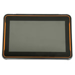
Intelligent Terminal |
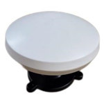
Antenna |
|
 |
 |
|
|
● 10.1-inch high-definition touch screen, clearly visible in sunlight |
● Support for Beidou/GPS/GLONASS/GALILEO/SBAS ● High reception sensitivity, improving vehicle positioning and navigation accuracy ● High-strength PC shell for durability |
|
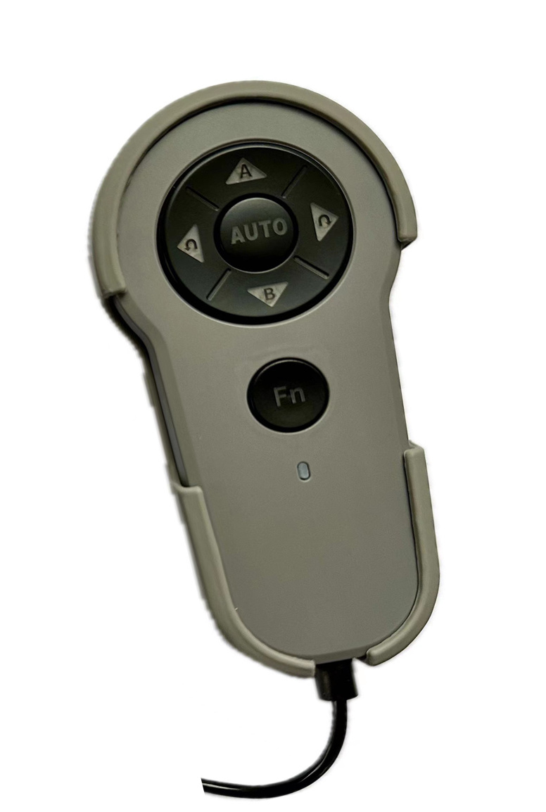
Control Handle |
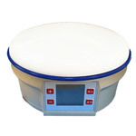
Portable Base Station |
|
 |
 |
|
| ● Easy to operate ● Dust and water proof, comfortable grip |
● Highly integrated design with built-in 4G, WiFi module, and three-axis acceleration sensor ● Stable signal transmission, effective transmission distance greater than 3km ● Supports hot swapping, ultra-low power consumption, powered by power bank ● Durable body, high-strength PC shell, IP67 protection level, resistant to 1m free fall |
|
|
||
| Water Saving | Land Saving | ||
|
|
||
| Fertilizer Saving | Grain Output Increase | ||
High Precision
● Using RTK real-time dynamic carrier phase difference technology to provide centimeter-level horizontal and elevation positioning accuracy
● Configurable control accuracy adjustment to meet the operation accuracy requirements in different scenarios, up to 1cm control accuracy
High Usability
● GNSS+INS fusion technology supports single-point rapid creation of target surfaces
● Automatic bucket height calibration
● Visualized heat map of elevation error, the operation effect is clear at a glance
● Supports automatic leveling, deeply optimizes the leveling control algorithm, and greatly reduces abnormal phenomena such as planing pits and flying shovels in the process of leveling
High Adaptability
● Supports control of graders, scrapers, and can be adapted to mainstream grader types on the market
Intelligent Terminal
● 10.1-inch high-definition touch screen, clearly visible in sunlight
● Internal integrated controller, effectively improving system reliability
● Built in high-precision positioning board, radio station, and 4G network module
● IP67 protection level, dust and water proof
● -40~70 ℃ ultra wide working temperature range, suitable for extreme operating conditions
Antenna
● Support for Beidou/GPS/GLONASS/GALILEO/SBAS
● High reception sensitivity, improving vehicle positioning and navigation accuracy
● High-strength PC shell for durability
Control Handle
● Five buttons, easy to operate
● Dust and water proof, comfortable grip
Portable Base Station
● Highly integrated design with built-in 4G, WiFi module, and three-axis acceleration sensor
● Stable signal transmission, effective transmission distance greater than 3km
● Supports hot swapping, ultra-low power consumption, powered by power bank
● Durable body, high-strength PC shell, IP67 protection level, resistant to 1m free fall
MESSAGE BOARD
Tel.
Mobile:+86 185 6159 2559
Email: sales@wisdombeidou.com
Address:No. 3-32 Changjiang Road, Pingdu ETDZ, Qingdao City, China
Copyright © Wisdom Beidou | SEO | Business license